FRESH AIR
“Disappearing Palestine” – the Maps that Lie
July 7, 2020 | Judy Maynard

Appearing regularly in pro-Palestinian books, articles, social media and websites here and overseas – and even in mainstream media – is a series of maps purporting to show the gradual Palestinian dispossession of their land at the hands of the Jews/Israelis. Usually shown as a group of four, their simple (though explanation-free) format appears to lend historic weight to an inescapable conclusion: that Israel is guilty of systematic land theft.
Their problem is that this series of maps is riddled with misrepresentations and omissions, and their overall narrative is an outright lie.
The origin of these maps is unclear; the earliest known reference to them appears to be in a 2003 book which attributes them to the “Palestine Solidarity Campaign,” a British group supporting the “BDS” movement (urging boycott, divestment and sanctioning) against Israel.
The maps have become an iconic feature of Palestinian propaganda literature in recent years and something of an industry, available for purchase even on tea towels and mugs. Their occasional use by the media has sometimes resulted in a correction or deletion. That hasn’t prevented their use by a few mainstream Australian sites, including News Corp Australia’s multiplatform news.com.au in 2014.


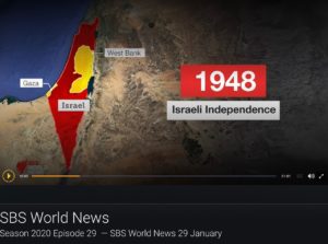

The public broadcaster SBS Television used them earlier in the year to illustrate a report about the Trump peace plan. With the maps displayed, SBS reporter Helen Isbister commented, “It comes more than a century since colonial power Britain approved the establishment of a national home for Jews in Palestine, with Palestinian territory shrinking significantly since then, including when the state of Israel was proclaimed in 1948, and with further reductions to come…”. That commentary was as erroneous as the accompanying graphics.
The maps usually begin with one labelled 1946. The Uniting Church features on its website another stock version that claims to “demonstrate” that in 1946 “more than 90 percent of the land” belonged to the Palestinians. It does nothing of the sort; it merely presents a map almost entirely one colour and labels this “Palestinian”.
As in the map appearing at the top, small patches are labelled “Jewish land”; everything else is claimed as Palestinian. While the small patches may correspond reasonably accurately with the land then privately held by Jews, the rest of the map is a lie. The totality of the remaining area was not in any sense “Palestinian”, whether this refers to ownership, control, or even simply habitation.
Ottoman land ownership laws were complicated and the state of land registration chaotic under both the Ottomans and the British. But it is clear that only a very small percentage of land in Palestine was privately owned; the great majority was government land. While it is true that the Jews owned only a small percentage, the Arabs owned only slightly more. But that is not the impression this map seeks to convey.
This methodology continues past distortions. For example, a map prepared by the UN “Subcommittee on the Palestine Question” purporting to show land ownership by sub-districts in 1944 shows less than 1% Jewish ownership in the Beersheba district, and 99% non-Jewish. However as that 99% was government land it was also 99% non-Arab/non-Palestinian.
The map therefore dishonestly treats all significant tracts of “non-Jewish” land as Palestinian by default, even though Palestinian Arabs may have had little or no ownership, control or presence there. The Negev, for example, of which Beersheba is today the administrative capital, is largely rocky desert accounting for more than 50% of present-day Israel. Even today it is sparsely inhabited, yet it too is claimed as almost entirely “Palestinian land” in 1946.
The Qatari government-controlled media organisation Al Jazeera uses a so-called infographic which substitutes the 1946 map with one purporting to illustrate the situation in 1917.
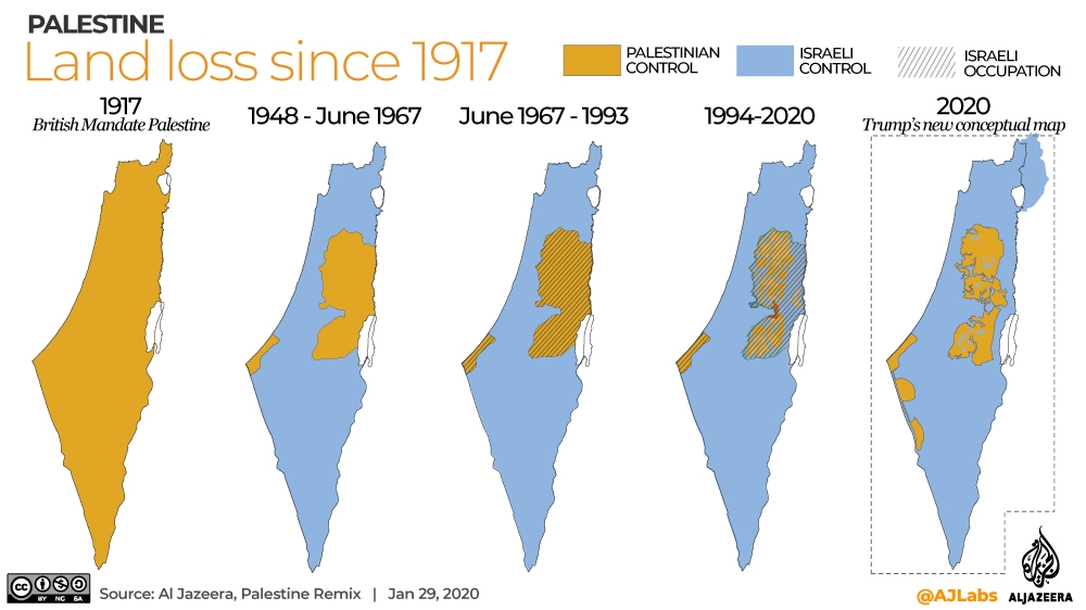
Everything about this 1917 map is factually incorrect.
The map is labelled “British Mandate Palestine”, yet fails to show that the Mandate initially included Transjordan. Furthermore, the League of Nations Mandate for Palestine did not commence until 1922. At the start of 1917 , Palestine was still part of the Ottoman Empire, following whose defeat in World War 1 the area came under interim government by the Occupied Enemy Territory Administration.
The claim, therefore, that the area was under “Palestinian control” in 1917 (as is signified by colouring the whole area brown) is simply false.
Generally such maps do not, as this one does, specify land as being under the “control” of either Palestinians or Jews/Israel, but rather use the more ambiguous terms “Palestinian land” and “Jewish (or Israeli) Land”.
The next map in the series at the top is labelled “UN Plan 1947” which was and is just that: a plan. Moreover it was a plan vehemently rejected by the Palestinian leadership and the Arab states. As this map reflects no real situation that ever existed on the ground, it is totally irrelevant to a supposed history of Palestinian land ownership. What it seeks to do, however, is create another chapter in a fictional tale of gradual and deliberate dispossession, whereas the truth is that expansion of Israeli territory has come as a consequence of its victories in fighting defensive wars. Moreover, it is Israel that has facilitated Palestinian autonomous control of land for the first time ever – as will be discussed below.
The next map, labelled 1949-1967, is a case in point. It suffers not only from factual inaccuracies, but also from the omission of crucial historic detail. With the end of the British Mandate at midnight on 14 May 1948, followed by Israel’s declaration of independence, neighbouring Arab countries invaded with the aim of crushing the new Jewish state but were unsuccessful. As a result, Israel gained control over a greater area of land than had been designated for the Jewish state under the UN Partition Plan rejected by the Palestinians.
The borders between the white and green areas show the 1949 armistice lines, but the green areas – Gaza and the West Bank – are falsely labelled Palestine. They were neither owned nor controlled by the Palestinians but occupied by the invading armies of respectively Egypt and Jordan. Jordan went on to formally annex the West Bank.
Israel’s victory in the 1967 Six Day War saw it once again increase its territory, gaining the West Bank, Golan Heights, Sinai Peninsula and Gaza. Subsequent peace treaties with Egypt (1979) and Jordan (1994) saw Israel withdraw from the Sinai Peninsula and resolve land issues with Jordan.
The final and least inaccurate map in the series, usually labelled 2005 or later, shows in green an approximation of political control exercised by the Palestinians, although not differentiating between areas governed by the Palestinian Authority (PA) in the West Bank and by Hamas in the Gaza Strip. Pursuant to the Oslo Accords of 1993 and 1995 Israel transferred powers and responsibilities to the PA in parts of Gaza and the West Bank, and in 2005 withdrew completely from Gaza, handing control to the PA – which it then lost to Hamas in a violent coup.
What this map does convey accurately is that, as a result of the 1990s peace process, Palestinians exercised control over land – the first time this was ever the case.
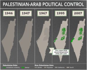
To illustrate this point, Israeli-born academic Shany Mor has developed his own series of maps which accurately show the historical development of Palestinian/Arab political control in the region:
Tags: Al-Jazeera, Palestine, Qatar
RELATED ARTICLES


Australia gripped by the plight of the Iranian women’s football team: Dionne Taylor on GB News

Enormous hope that Iran is being liberated: Colin Rubenstein on Sky News


