UPDATES
A map essential to understanding Israel’s decision to declare 1000 acres of land in the Etzion bloc “state land”
Sep 9, 2014 | Gabrielle Debinski

There has been fierce debate and confusion regarding the recent decision of Israel’s civil administration to declare 988 acres of land in the West Bank Gush Etzion area as “state land.” The decision, announced by the Israeli government on August 31, is reportedly the precursor for the expansion of the small Gva’ot settlement into a much larger town.
Almost immediately after making the pronouncement, the Israeli government came under fire from the US, the EU and the Palestinian Authority, with such condemnations reverberating throughout the international press. Yet, as Dr Tzvi Fleischer highlighted in an AIJAC blog post last week, much of the critique circulating in the press omits essential background information regarding where this land is and what this move actually means.
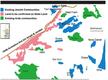
Now the crucial geographical context is made very clear in a map developed by Israeli- based think tank, Regavim, using GIS software to amalgamate maps released by Israel’s civil administration (see below). It shows that the land in question abuts the 1949 armistice line and arguably does not encroach on any existing Arab communities.

Additionally, this map also reveals that the land to be confirmed by Israel’s civil administrative as “state land” (codified in pink) is completely uninhabited. Hence, this move does not really alter the geopolitical landscape – and certainly does not complicate future Palestinian statehood in any significant way.
Meanwhile, contrary to the arguments touted by US Secretary John Kerry, and adopted by much of the media, a prominent international law expert has taken on claims that this move amounts to an “expropriation” of Palestinian land.
In an article published in the Washington Post, Professor at Northwestern University School of Law, Eugene Kontorovich, explains that “Israel’s action is not a seizure, a taking, condemnation, expropriation, or confiscation. Nor does it establish a new settlement, expand settlements, or in any way change the demographics of the territory.”
Referring to earlier comments he made in Commentary magazine, Kontorovich explains the legal nuances:
“An ‘appropriation’ involves taking something that is someone’s. A designation of land as “state land” requires a determination, based on extensive investigation, that it does not have a private owner. The determination can be challenged administratively and judicially, as Palestinian claimants often do, and sometimes prevail.”
“In other words, nothing has been taken from anyone, or given to anyone. Thus a “state land” determination does not create any new facts or change ownership. Moreover, designating an area state land does not mean that a Jewish community can be built on it. Both illegal Jewish and Arab building on state land is often demolished. Authorizing a new residential community would require a vast number of additional administrative and political permissions, none of which appear to be remotely forthcoming.”
Finally, Elliot Abrams, a former American national security council advisor responsible for Arab-Israel issues, has looked at the big picture on settlement expansion in the wake of recent figures put out by Israel’s Central Bureau of Statistics which show that Israel’s settlement construction pace has actually reached historically low levels. Writing for Foreign Policy, Elliot Abrams notes that despite this significant fall in Jewish settlement construction there have been no concrete concessions made on the Palestinian side.
Abrams states:
“Only 507 housing units were approved for construction by Netanyahu’s government in the first six months of 2014, a 71.9 percent decrease from the same period in 2013, with about one-third of those being built inside the major blocks that it is understood Israel will keep in any final status agreement. For a population of over 300,000 Israelis living in the West Bank, that pace of construction does not even allow for natural population growth, much less rapid expansion.”
“Only in 2010 did Israel build at a slower pace — 738 units for the whole year — and that was the year of a nine-month construction moratorium imposed by Netanyahu at the request of the United States. This partial freeze, by the way, produced no Palestinian concessions and no progress in the ‘peace process’ whatsoever.”
Commenting on the issue of the declaration of “state land” in the Gush Etzion bloc, as shown in the map, Elliot Abrams aptly sums up the realities:
“At the end of the day, the annexation is a symbolic move. Those lands are going to remain Israel’s no matter what: They are populated by some 20,000 Israelis [Abrams is here including adjacent settlements- Ed.], adjacent to the pre-1967 border, and were recognized in previous negotiations as part of the areas Israel would keep and for which it would swap Israeli land elsewhere. Most recently, the leaked “napkin map” of the 2008 negotiations between Israeli Prime Minister Ehud Olmert and Palestinian President Mahmoud Abbas marked all 1,000 acres as falling under eventual Israeli control…”
He concludes:
“Anyone who’s serious about addressing the Israeli-Palestinian conflict should ignore the speeches and the rote condemnations, and study the numbers. The vast expansion of Israeli settlements in the future Palestinian state is simply not happening.”
Gabrielle Debinski
Tags: Israel


